Sedona Stargazing Guide
Where and When to Stargaze
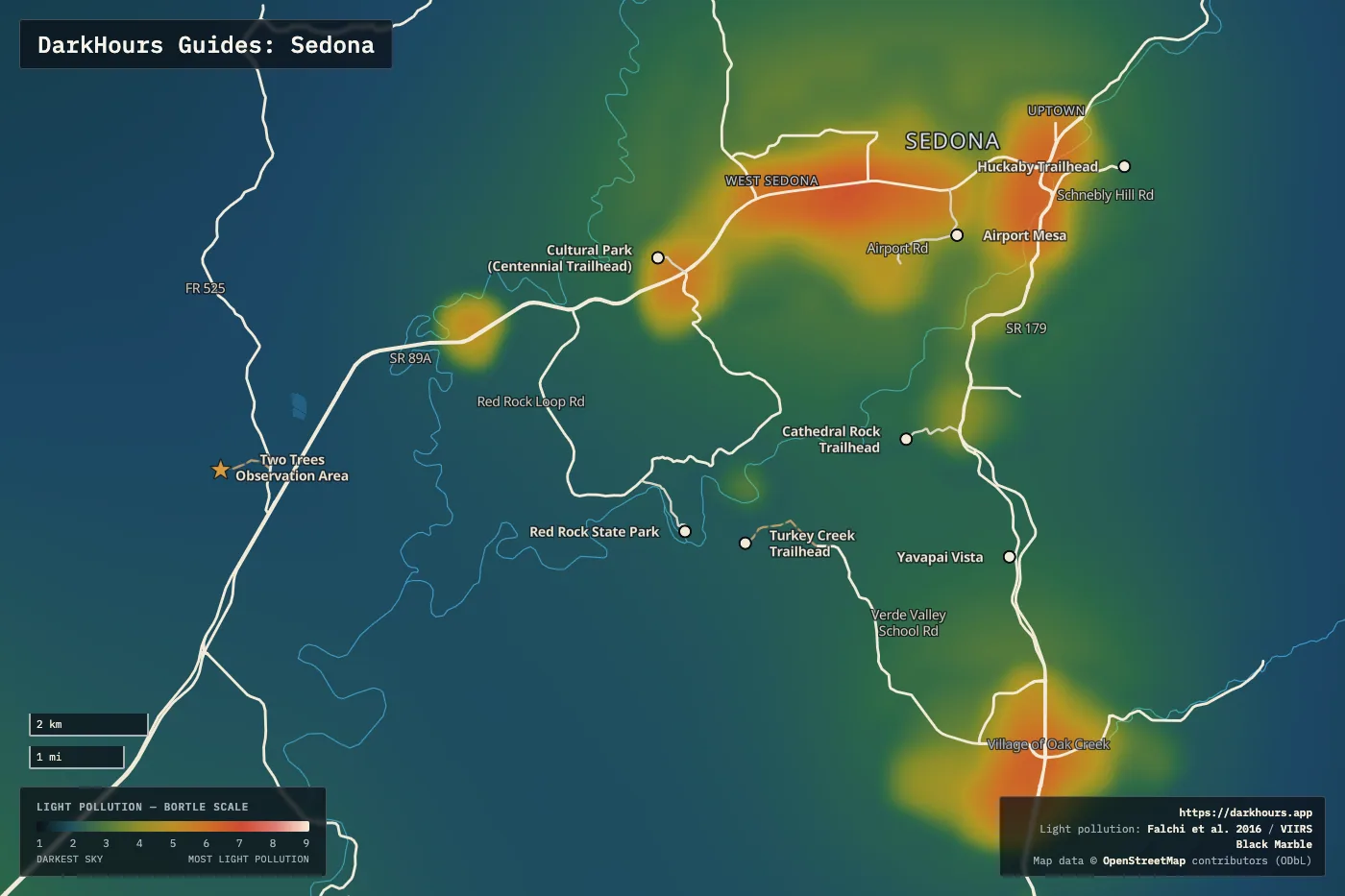
- Where: The darkest sky close to town is at the Two Trees Observation Area, a free open field in Coconino National Forest off SR 89A between Sedona and Cottonwood. It rates Bortle 2. The Cultural Park area in West Sedona and the Huckaby Trailhead on Schnebly Hill Road are closer to town and rate Bortle 3. These spots were picked because they're easy to reach. Bortle 1 skies are about 90 minutes' drive east of Sedona, around Happy Jack, and are listed under Dark Sky Nearby below.
- When: The Milky Way core is up from February through October and peaks in June at about 26° above the southern horizon. Arizona stays on Mountain Standard Time all year, so the times on this page never shift for daylight saving.
- Moon: Plan your trip around the new moon. The outlook table below picks the darkest night in each of the next six months.
- Programs: Red Rock State Park holds star parties with the Astronomers of Verde Valley. Registration is required, and dates are on the park's events calendar.
Location Overview
Sedona is in Red Rock Country at the southern edge of the Colorado Plateau, surrounded by the Red Rock Ranger District of Coconino National Forest. In 2014 DarkSky International named the city the world's eighth International Dark Sky Community. The Community program recognizes towns for their outdoor lighting standards and public outreach. Sedona's lighting ordinance became law in 2001 after years of work by city staff and the local nonprofit Keep Sedona Beautiful, and the city has paid to retrofit older fixtures.
The best stargazing in Sedona is just outside town, because the city still gives off light. This page's reference point is the Two Trees Observation Area, an open field on national forest land west of town. Local astronomy clubs call it the Two Trees Observing Area. The sky there rates Bortle 2 on the Bortle scale, with a sky brightness of 21.75 magnitudes per square arcsecond. On the map, uptown, West Sedona and the Village of Oak Creek show as bright patches. The forest around the field stays dark.
From Two Trees, the brightest glow in the Sedona night sky comes from the city itself, 5 to 8 miles to the east and northeast. It rises to about 19° above the horizon. A smaller glow lies about 25 miles to the southwest. Phoenix is 73 miles away and shows as a thin band just above the southern horizon. The northwest is the darkest part of the sky. At 34.8° north, the Milky Way core reaches 26° above the horizon in June when it crosses due south, far above the Phoenix glow.
Night Sky & Weather Conditions
The Two Trees field is at about 3,900 feet in the Verde Valley. Bring a warm layer even after a hot day, because you'll be standing still for hours.
Arizona's summer monsoon brings afternoon thunderstorms and cloud buildup, mostly from July into September. Storms can build or linger into the night, so check the forecast late in the day. Winter nights are the longest. The core is out of view from November through January, so winter is better for deep-sky targets than for the Milky Way. Check the NWS Flagstaff forecast for the Verde Valley before you drive out.
Tonight at Sedona
Six-Month Moon & Darkness Outlook
| Month | Mean dark hours | Best night | Meteor showers |
|---|---|---|---|
| October 2026 | 5.0 h | Oct 19 · 5.1/10 | Orionids |
| November 2026 | 5.7 h | Nov 6 · 9.8/10 | Northern Taurids (favourable), Southern Taurids, Leonids |
| December 2026 | 6.0 h | Dec 6 · 9.8/10 | Geminids (favourable), Ursids |
| January 2027 | 6.0 h | Jan 4 · 9.8/10 | Quadrantids |
| February 2027 | 5.4 h | Feb 3 · 9.8/10 | — |
| March 2027 | 5.0 h | Mar 4 · 9.8/10 | — |
Dark Sky Nearby
Distances and drive times below start from central Sedona.
| This guide's spots | Bortle | SQM | Dist | Drive | Dir |
|---|---|---|---|---|---|
Huckaby TrailheadParking | 3 | 21.5 | 3 mi | 6 min | ENE |
| 3 | 21.4 | 4 mi | 7 min | W | |
Two Trees Observation AreaObservatoryDirt roads | 2 | 21.8 | 10 mi | 13 min | WSW |
| 3 | 21.6 | 8 mi | 18 min | SW | |
Turkey Creek TrailheadParkingDirt roads | 3 | 21.6 | 13 mi | 27 min | SSW |
Other dark spots within 30 miles:
Scouting & Foregrounds
- Two Trees Observation Area — This page's reference point and the darkest spot here, at Bortle 2. The Sirius Lookers astronomy club gives this route. Leave SR 89A heading west on Forest Road 525. After about a third of a mile of dirt road, take the left branch at a large fork. The observing field is a small open area on the left, about 200 feet before a radio-controlled model airplane field. The Astronomers of Verde Valley publish a map of the same spot. There are no facilities. The dirt stretch is short. Drive it slowly, and make your first trip in daylight.
- Cultural Park (Centennial Trailhead) — The easiest spot in town, in the Cultural Park area of West Sedona. Visit Sedona lists the Centennial Trailhead as a stargazing spot. From SR 89A, turn onto Cultural Park Place and follow it 0.1 miles to the trailhead parking. A paved path leads out from the lot. You don't have to hike or drive a dirt road. It's at the western edge of town and rates Bortle 3. Use it on nights when you don't want to drive far.
- Turkey Creek Trailhead — Southeast of Red Rock State Park, away from the town's lights, at Bortle 3. The Forest Service gives these directions. From the SR 89A and SR 179 junction, take 179 south 7.2 miles. Turn right at the signal onto Verde Valley School Road and go 4.1 miles to the road on the left signed for Turkey Creek Trail. That unpaved road is rough but passable by any vehicle. Take it 0.5 miles, then take the left fork 100 feet to the end.
- Huckaby Trailhead — On Schnebly Hill Road east of uptown, at Bortle 3. Sirius Lookers observes from the lot just before the pavement ends, and there is a restroom. To get there from the SR 89A and SR 179 junction, per the Forest Service, take 179 south 0.3 miles. Turn left onto Schnebly Hill Road across the Oak Creek bridge and go 0.8 miles to the turnoff signed for the Margs and Huckaby trails. The lot is at the edge of the uptown glow. This is a Red Rock Pass site.
- Red Rock State Park — Bortle 3. The park's star parties with the Astronomers of Verde Valley start with a short talk about the night sky. Then you look through the club's telescopes. Registration is required, and the park charges an entrance fee. Regular hours end at 5 p.m., so you can only see the sky from inside the park during these events.
- Airport Mesa — Sedona's popular sunset overlook, in the middle of town. We don't recommend it for stargazing. Cars come and go all evening, and the city's lights surround the mesa. It makes a nice nightscape photo, with the lit city spread out below the stars.
Logistics & Access
Several Sedona-area trailheads and vistas are Forest Service fee sites, including Huckaby Trailhead, Yavapai Vista and Cathedral Rock Trailhead. If you leave your vehicle at one, you need a Red Rock Pass or an America the Beautiful pass. A Red Rock Pass costs $5 a day, $15 a week or $20 a year. You can buy one at the kiosk machines at the fee sites or online through Recreation.gov, where the pass is tied to your license plate. Two Trees, the Centennial Trailhead and the Turkey Creek Trailhead aren't on the Forest Service's fee-site list.
Two Trees has no facilities, so bring water, a warm layer and a red light. If club members are already set up, pull in slowly and switch off your headlights as soon as you park. Download star charts and directions before you leave town.
Sedona has many paid stargazing tours with guides and telescopes. This guide is for going on your own. If you'd like an introduction first, go to a Red Rock State Park star party. Club members bring larger telescopes and can show you what you're looking at.