Zion National Park Dark Sky Guide
Location Overview
Zion National Park sits at the junction of the Colorado Plateau, Great Basin, and Mojave Desert in southwestern Utah. Checkerboard Mesa, this page's reference point, is a Navajo sandstone dome on the park's east side, along the Zion–Mount Carmel Highway (SR-9) about 4 miles inside the East Entrance, at roughly 5,656 ft — about 1,700 ft higher than Zion Canyon's floor near the visitor center (~3,900 ft). It's a roadside pullout with an open view of the mesa's cross-bedded sandstone face and the surrounding terrain.
Night Sky & Weather Conditions
High desert canyon climate: clear skies are prevalent outside monsoon season, and mid-June is peak Milky Way core season with generally settled weather — the core clears the horizon due south after midnight, peaking around 1:43 AM on a mid-June night. Southern Utah's weather can be difficult to forecast, especially as the monsoon-season moisture (mid-Jul–Sep) brings afternoon cloud buildup and thunderstorms. Most years, this is the same pattern behind Zion's Narrows flash-flood warnings — so check the forecast before committing to a night out. Checkerboard Mesa sits on the park's higher east-side plateau rather than the canyon floor, so nights run cooler here than trip reports centered on Zion Canyon or Springdale would suggest — pack layers accordingly. Winter (Dec–Feb) can bring snow and icy sections on SR-9's plateau approach; check road conditions before a winter-night drive. Outside monsoon season, wind is the more common spoiler on this exposed sandstone terrain than cloud cover.
Tonight at Zion National Park
Six-Month Moon & Darkness Outlook
| Month | Mean dark hours | Best night | Meteor showers |
|---|---|---|---|
| July 2026 | 0.0 h | Jul 29 · 0.0/10 | — |
| August 2026 | 3.4 h | Aug 13 · 10.0/10 | Perseids (favourable) |
| September 2026 | 4.2 h | Sep 11 · 10.0/10 | — |
| October 2026 | 4.9 h | Oct 9 · 10.0/10 | Orionids |
| November 2026 | 5.7 h | Nov 6 · 10.0/10 | Northern Taurids (favourable), Southern Taurids, Leonids |
| December 2026 | 6.1 h | Dec 6 · 10.0/10 | Geminids (favourable), Ursids |
| January 2027 | 5.9 h | Jan 4 · 10.0/10 | Quadrantids |
Dark Sky Nearby
Already at Bortle 1 (SQM 22.0) — showing other Bortle 1 sites within 60 mi.
| Area | Bortle | SQM | Dist | Drive | Dir |
|---|---|---|---|---|---|
| 1 | 22.0 | 0 mi | 0 min | N | |
| 1 | 22.0 | 0 mi | 0 min | N | |
High Road CampgroundThe State of Utah School and Institutional Trust Lands Administration 731Campsite | 1 | 22.0 | 1 mi | 3 min | ENE |
Poverty Gulch Rim OverlookViewpointDirt roadsLast 1 mi not drivable | 1 | 22.0 | 5 mi | 10 min | ESE |
Poverty Gulch OverlookThe State of Utah School and Institutional Trust Lands Administration 719ViewpointDirt roadsLast 2 mi not drivable | 1 | 22.0 | 6 mi | 12 min | ESE |
| 1 | 22.0 | 6 mi | 17 min | NNE | |
Zion Ponderosa Ranch ResortCampsite | 1 | 22.0 | 9 mi | 24 min | N |
| 1 | 22.0 | 10 mi | 27 min | NNW | |
East Mesa Trailhead Parking;East Mesa / Observation Point Trailhead ParkingZion National ParkParking | 1 | 22.0 | 11 mi | 31 min | NNW |
Powell PlaqueHistoric siteLast 2 mi not drivable | 1 | 22.0 | 45 mi | 1 hr 21 min | SSE |
Scouting & Foregrounds
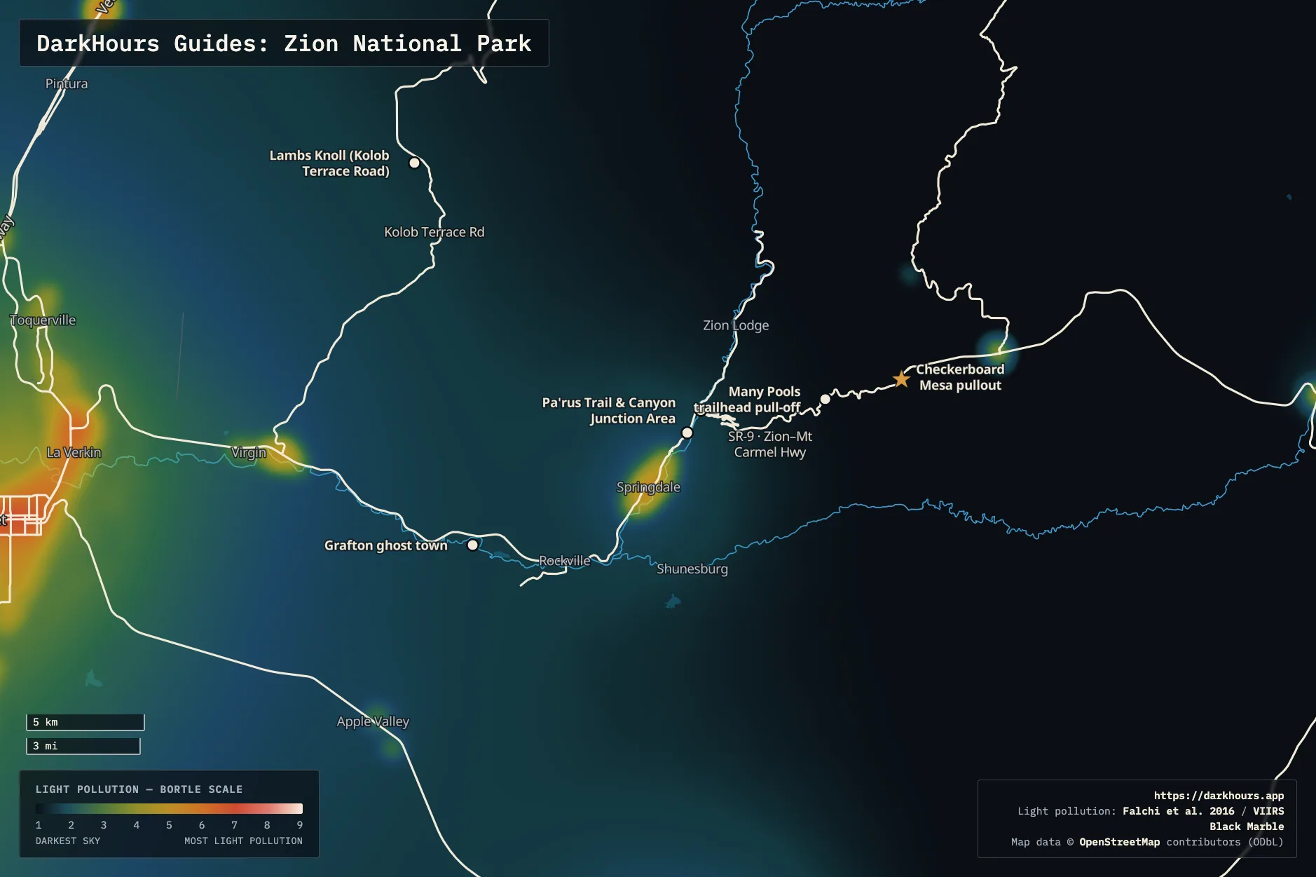
- Checkerboard Mesa pullout — This page's reference coordinate — a roadside pullout on SR-9 facing the mesa's namesake checkerboard sandstone face, with the Milky Way rising directly over the mesa's peak. Light domes to the W and SW (Springdale/St. George's glow) read as minor; the darkest sky here is to the SE, away from town.
- Many Pools trailhead pull-off — Small parking pull-off on SR-9 about 2 miles west of Checkerboard Mesa — room for roughly 9-10 vehicles, plus restrooms. Viewing from the pull-off itself, no need to walk the (unofficial, unmarked) trail after dark. Same sky profile as Checkerboard Mesa — light domes minor to the W/SW, darkest to the SE.
- Canyon Junction — At the south end of the park, where SR-9 crosses the Virgin River bridge and meets Zion Canyon Scenic Drive. A roadside pull-off, often deserted and quiet after dark despite sitting close to Springdale, with large mountains rising on both sides and a clear view of the Milky Way core. Light pollution is slightly worse than Checkerboard Mesa, and Springdale's glow puts major domes to the W and SW, but it's still Bortle 2.
- Human History Museum — About a quarter mile from Canyon Junction, on Zion Canyon Scenic Drive near the South Entrance. The Museum patio and parking lot are good spots to catch the Milky Way core rising here over The Watchman — the iconic peak dominates the view south. Same general light pollution profile as Canyon Junction (Bortle 2, major W/SW domes from Springdale), and the easiest of these to reach: paved parking, no hike. Note some nights can be quite windy in this section of the canyon.
- Pa'rus Trail — A paved, flat, wheelchair-accessible trail along the Virgin River connecting Canyon Junction to the visitor center/South Campground area (1.7 miles one-way). Several spots along the first 15-20 minutes of walking from the Canyon Junction end have open views of the Milky Way rising over The Watchman. It's an easy walk as the trail is paved and level the whole way — no separate trailhead parking is needed if you're already at Canyon Junction.
- Grafton ghost town — A preserved 1859 Mormon settlement near Rockville, just south of the park — not NPS land (the Grafton Heritage Partnership Project manages it), but free and open to the public. Reached via a ~3.5-mile road from Rockville, unpaved for the last 2 miles, across the Virgin River from the highway. Genuinely darker than the Canyon Junction/ Human History Museum area despite being close by — Bortle 2, only minor light domes, since the townsite itself has no lights of its own. The preserved wooden buildings and cemetery (a film backdrop for Butch Cassidy and the Sundance Kid) make for a distinctive foreground unlike anything else on this page.
- Lambs Knoll (Kolob Terrace Road) — A BLM climbing area, not Zion NP — well outside the park's east and south sides covered above. From SR-9 just east of Virgin, UT, head 10.6 miles north on Kolob Terrace Road, then 0.2 miles on the access road to a developed trailhead (paved lot for any vehicle, picnic area, restroom, 8 first-come walk-in campsites). Primarily known for its 25+ sandstone climbing routes, but the parking area works for stargazing too. Meaningfully more remote than the south-end spots — even at the road's junction with SR-9, still miles from Springdale, it's already Bortle 3 with only minor domes; the trailhead itself, 10+ miles farther from town, should be at least as dark.
Logistics & Access
Zion's standard per-vehicle entrance fee is $35 for 7 consecutive days as of this writing — check the official fees page for the current rate. Most lodging and services cluster in Springdale, just outside the South Entrance — it's only about a 35-minute drive across the park to the East Entrance side, where Checkerboard Mesa and Many Pools sit. Accommodations on the east side are more limited, but the area is markedly less developed and less crowded than Springdale, with less light pollution. Checkerboard Mesa is on the park's east side, reachable directly from the East Entrance off US-89 without passing through the Zion–Mount Carmel Tunnel. If you're instead coming from Zion Canyon or Springdale, note that the tunnel and the highway between Canyon Junction and the East Entrance now bar essentially anything RV-sized or larger — a standard car or small SUV is fine, but check current size limits before towing anything. No permit is required for roadside stargazing at any of the pullouts above. Plan any night hike as a repeat of a trail you've scouted during the day. As with most NPS units, overnight parking and camping outside designated campgrounds isn't permitted.