Joshua Tree National Park Dark Sky Guide
Location Overview
Joshua Tree National Park sits where the Mojave and Colorado deserts meet in southeastern California. Arch Rock, this page's reference point, is a natural granite arch in the park's northern section, located a 5-minute walk from White Tank Campground near the Twentynine Palms entrance at roughly 3,800 ft. It's well below the park's higher western overlooks like Keys View. It's a foreground subject for night photography with open desert and rock in every direction.
Night Sky & Weather Conditions
High-desert climate: clear skies dominate most of the year. Summer nights (Jun-Sep) stay warmer here than at the park's higher western overlooks — 3,800 ft doesn't cool off like Keys View's 5,185 ft does, so bring lighter layers than you would to higher elevations. Occasional Southwest monsoon moisture (Jul-Sep) can bring afternoon cloud build-up and isolated thunderstorms. Check the forecast regularly. Winter nights (Dec-Feb) drop near freezing. The trail and campground sit in open, exposed desert with no windbreak, so wind — not cloud cover — is still the most common spoiler here.
Tonight at Joshua Tree National Park
Six-Month Moon & Darkness Outlook
| Month | Mean dark hours | Best night | Meteor showers |
|---|---|---|---|
| July 2026 | 0.0 h | Jul 29 · 0.0/10 | — |
| August 2026 | 3.5 h | Aug 12 · 9.6/10 | Perseids (favourable) |
| September 2026 | 4.3 h | Sep 10 · 9.6/10 | — |
| October 2026 | 5.0 h | Oct 8 · 9.6/10 | Orionids |
| November 2026 | 5.6 h | Nov 6 · 9.6/10 | Northern Taurids (favourable), Southern Taurids, Leonids |
| December 2026 | 6.0 h | Dec 6 · 9.6/10 | Geminids (favourable), Ursids |
| January 2027 | 5.8 h | Jan 4 · 9.6/10 | Quadrantids |
Dark Sky Nearby
| Area | Bortle | SQM | Dist | Drive | Dir |
|---|---|---|---|---|---|
| 2 | 21.7 | 7 mi | 11 min | SE | |
| 2 | 21.8 | 9 mi | 13 min | ESE | |
| 1 | 22.0 | 61 mi | 1 hr 3 min | NNE | |
Foo LionsAttractionDirt roads | 1 | 22.0 | 65 mi | 1 hr 4 min | NNE |
Iron Mountain Divisional CampHistoric siteDirt roads | 1 | 22.0 | 68 mi | 1 hr 4 min | E |
| 1 | 22.0 | 66 mi | 1 hr 6 min | NNE | |
Camp CoxcombHistoric siteDirt roads | 1 | 22.0 | 72 mi | 1 hr 7 min | E |
Route 66Historic siteDirt roads | 1 | 22.0 | 72 mi | 1 hr 11 min | NE |
| 1 | 22.0 | 80 mi | 1 hr 19 min | NNE | |
| 1 | 22.0 | 84 mi | 1 hr 26 min | NNE |
Scouting & Foregrounds
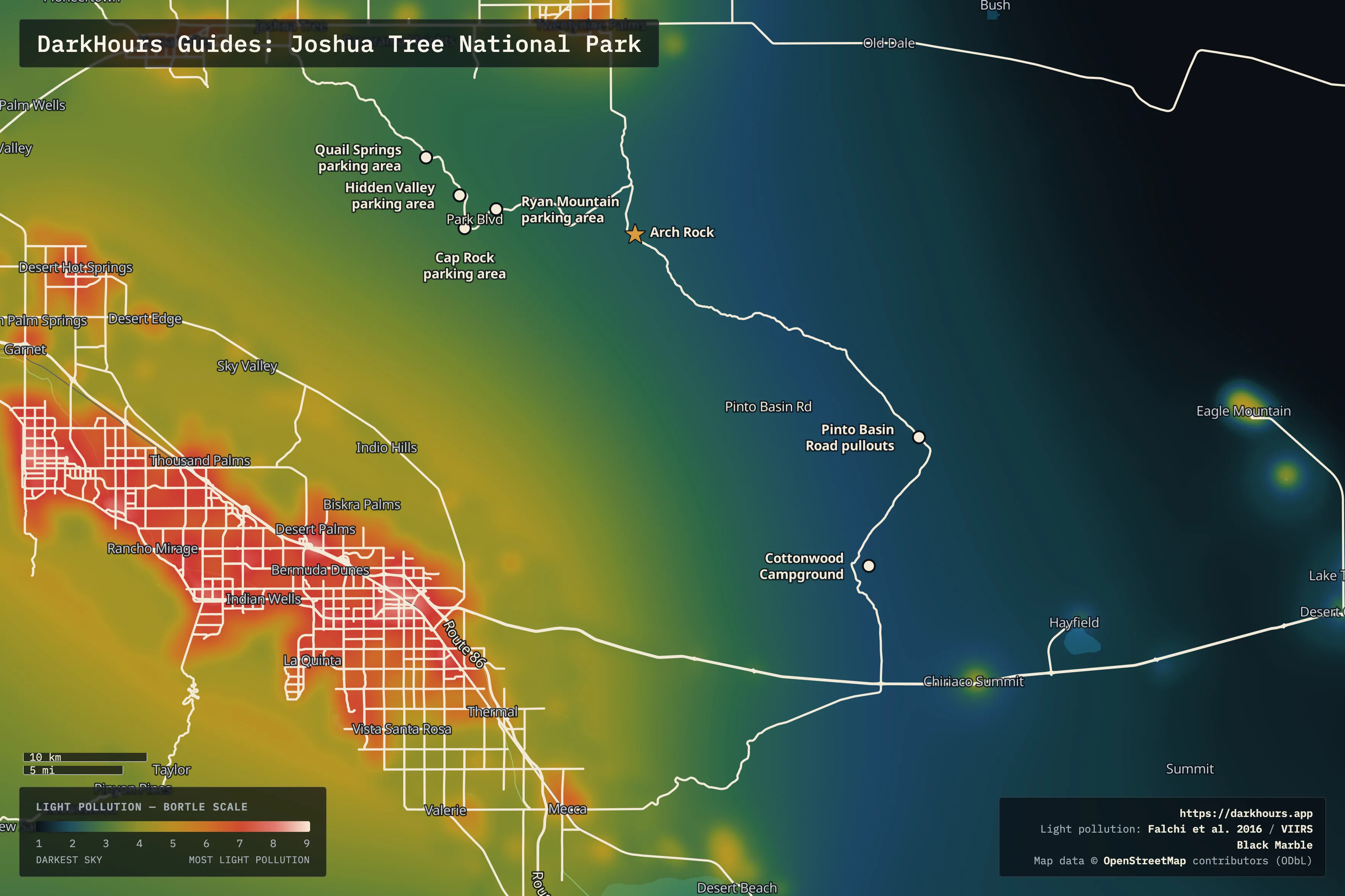
- Arch Rock — This page's reference coordinate — a natural granite arch, and well-photographed foreground subject for night photography, a 5-minute walk from White Tank Campground (trailhead opposite site 9; also reachable via the Twin Tanks parking area on Pinto Basin Road). The short loop trail (1.2 mi, ~90 ft gain) has no shade, water, or cell service. All five horizon light domes here — SW, W, S, NW, N — read as minor; the darkest sky is due east. Computed for a mid-June night: the Milky Way core peaks around 27° from the horizon, due south, at roughly 12:56 AM local time. There is a light dome to the south but it's the mildest of the group, so the loss of sky contrast is manageable.
- Hidden Valley parking area — One of four NPS-designated stargazing parking areas (with Cap Rock, Ryan Mountain, and Quail Springs below) — stay within 20 ft (6 m) of your vehicle after dark, no hike required. Hidden Valley itself is a rock-walled loop trail and picnic area, more centrally located in the park than Arch Rock and popular in daytime too, so expect more company early in the evening before it clears out.
- Cap Rock parking area — The second of NPS's four designated stargazing parking areas, same 20 ft rule. Named for the distinctive boulder formation right at the trailhead — a recognizable foreground if you want a landmark in the shot rather than open sky alone.
- Ryan Mountain parking area — The third of NPS's four designated stargazing parking areas. This is the trailhead lot, not the 5,457 ft summit itself — that's a strenuous 3-mile round trip with 1,050 ft of gain, not part of the stargazing designation. Same 20 ft rule applies at the lot; the parking area fills quickly in daytime but empties out well before dark most of the year.
- Quail Springs parking area — The fourth of NPS's four designated stargazing parking areas, same 20 ft rule, and the closest of the four to the park's West Entrance. A former ranching-era water source, now just a quiet pull-off.
- Cottonwood Campground — NPS's own pick for the park's darkest skies — the southeast corner, farther from the Coachella Valley glow to the southwest than Arch Rock. Unlike the parking-lot spots above, this is an actual campground: fee and reservation required, established sites, not a pull-off-and-look-up option.
- Pinto Basin Road pullouts — The stretch of Pinto Basin Road between Cholla Cactus Garden and Cottonwood — NPS's pick for the least foot traffic in the park. Roadside pullouts, no campground reservation needed; worth the extra drive from Arch Rock if minimizing other visitors matters more than the short walk Arch Rock itself offers.
Logistics & Access
Joshua Tree National Park never closes — it's open 24/7. If the entrance fee station is unstaffed when you arrive, you can proceed and pay later. The standard per-vehicle entrance fee applies; check the official fees page (linked below) for the current rate rather than trusting a cached number. No permit is required for stargazing or day use at the designated areas above. Some day-use areas close from dusk to dawn to protect wildlife — White Tank Campground and the Arch Rock trailhead are not among them and see regular use for sunrise and night photography. Access details can change and should be reverified in person or against a current NPS source and not assumed from this page. Overnight camping is only permitted in the park's designated campgrounds (fee + reservation) — not in parking lots or along roadsides. Bring warm layers and a red light; NPS's own guidance notes 20-30 minutes for full dark adaptation.