Death Valley National Park Dark Sky Guide
Location Overview
Death Valley National Park spans more than 3 million acres of the Mojave Desert along the California–Nevada line. It includes Badwater Basin, the lowest point in North America at 282 ft below sea level. The park rates Bortle 1 nearly everywhere in its interior — among the darkest skies in the National Park System, and consistent across every stop on this page. Its dark skies earned Gold Tier International Dark Sky Park certification in 2013. Zabriskie Point, this page's reference point, is a badlands overlook on the park's east side along CA-190, about 8 minutes' drive from Furnace Creek. It sits at roughly 710 ft, near the opposite end of the park's elevation range from Badwater Basin.
Night Sky & Weather Conditions
Extremely arid desert climate: average rainfall is under 2 inches a year, and sunny skies are the norm outside winter storms and the late-summer monsoon. Summer (Jun–Aug) is the most physically demanding season to be outdoors. Daytime highs regularly top 120°F (49°C), with overnight lows still in the 90s°F (32–37°C). It's also the Milky Way core's best month here. Computed for a new-moon night in early June, the core peaks around 25° above the southern horizon at roughly 1:41 AM local time. Spring (Feb–Apr) and fall (Sep–Oct) trade a lower, shorter core window for far milder nights. Spring can bring sudden dust storms. Late-summer monsoon moisture brings occasional thunderstorms with real flash-flood risk in the park's washes and canyons. Golden Canyon and Natural Bridge below both sit in that kind of terrain. Both tend to clear fast given how dry the region is, but check the forecast before committing to a night out regardless of season.
Tonight at Death Valley National Park
Six-Month Moon & Darkness Outlook
| Month | Mean dark hours | Best night | Meteor showers |
|---|---|---|---|
| July 2026 | 0.0 h | Jul 31 · 0.0/10 | — |
| August 2026 | 3.4 h | Aug 13 · 10.0/10 | Perseids (favourable) |
| September 2026 | 4.2 h | Sep 11 · 10.0/10 | — |
| October 2026 | 4.9 h | Oct 9 · 10.0/10 | Orionids |
| November 2026 | 5.7 h | Nov 6 · 10.0/10 | Northern Taurids (favourable), Southern Taurids, Leonids |
| December 2026 | 6.0 h | Dec 6 · 10.0/10 | Geminids (favourable), Ursids |
| January 2027 | 5.9 h | Jan 4 · 10.0/10 | Quadrantids |
Dark Sky Nearby
Already at Bortle 1 (SQM 22.0) — showing other Bortle 1 sites within 60 mi.
Scouting & Foregrounds
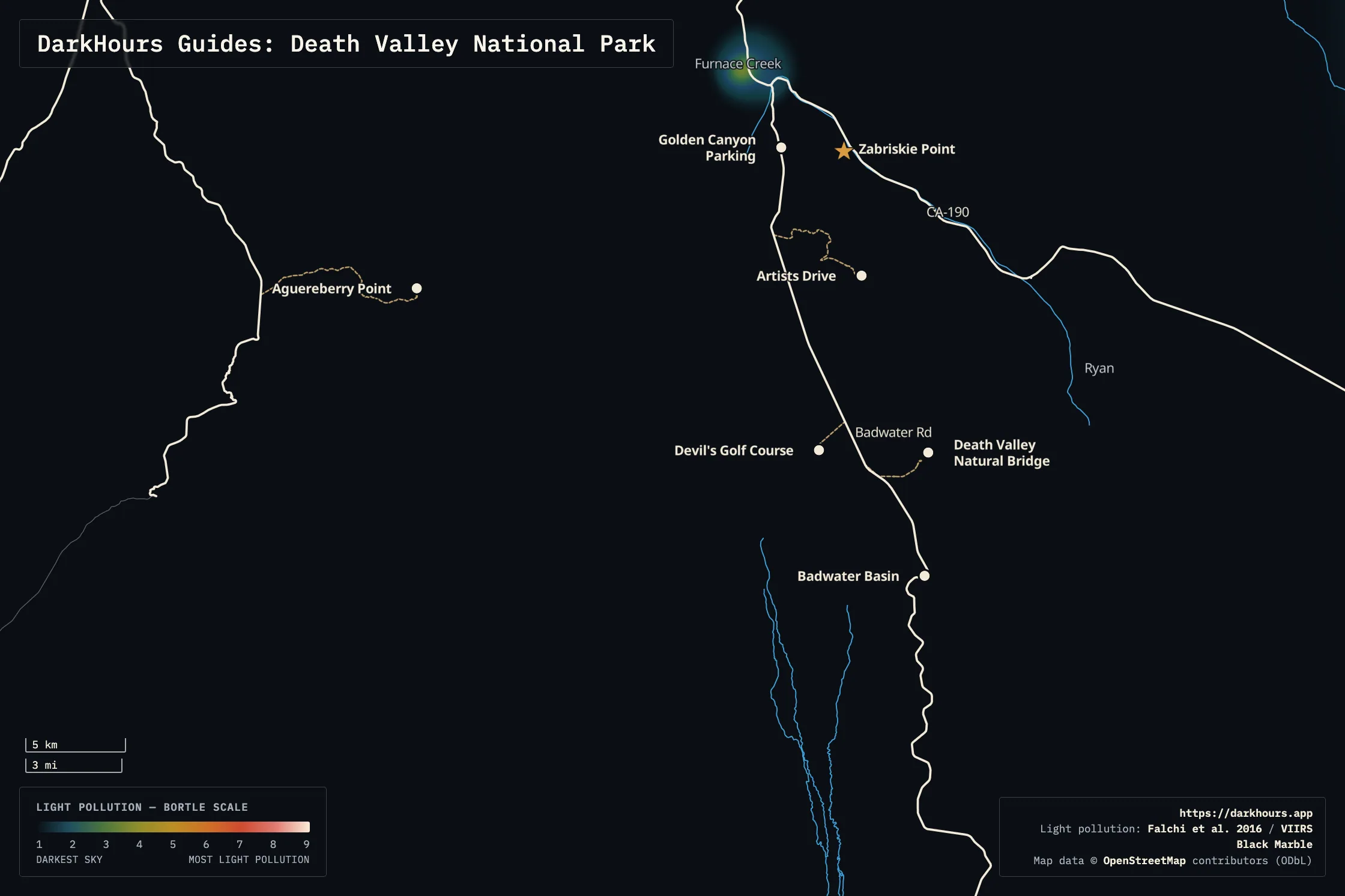
- Zabriskie Point — This page's reference coordinate, along CA-190 on the park's east side. It looks out over the golden, wind-carved badlands of the ancient Furnace Creek Formation. It's a well-known sunrise and sunset spot that's just as striking after dark, with the Milky Way arching overhead. The park's only light dome here is a minor one to the E (the Las Vegas area's glow); the darkest sky is to the NE. A maintained trail also drops from Zabriskie Point through the badlands and Red Cathedral down to Golden Canyon — a 7.8-mile round trip for day scouting.
- Golden Canyon Parking — A paved trailhead lot with a vault toilet, about 8 minutes from Zabriskie Point — the start of the Golden Canyon hike through golden-walled badlands toward Red Cathedral, and the other end of the trail up to Zabriskie Point itself.
- Badwater Basin — The lowest point in North America, a vast white salt flat about 23 minutes south of Zabriskie Point. View it from the parking area, or walk out onto the salt pan — there's no marked trail, so follow a path others have already walked to limit damage — for an open horizon in every direction.
- Devil's Golf Course — A jagged expanse of eroded rock-salt spires on the way to Badwater Basin, about 23 minutes from Zabriskie Point via a dirt access road. NPS guidance is to view it from the parking area rather than walk out onto the formations — the salt spires are sharp and fragile, more so after dark.
- Artists Drive — A nine-mile, one-way paved loop through volcanic badlands (25 ft vehicle-length limit for its tight turns), with Artists Palette as its signature overlook roughly 20–30 minutes from Zabriskie Point. The rainbow hillside colors that give the drive its name are a daytime draw; after dark it's a quiet pull-off with open sky, off the main Badwater Road traffic.
- Death Valley Natural Bridge — A short, easy walk up a wash to a 35 ft rock-and-gravel span, reached via a dirt road (generally well-maintained, but washouts and ruts do happen) about 22 minutes from Zabriskie Point. Quieter than the Badwater Road stops above.
- Aguereberry Point — A remote overlook high in the Panamint Range foothills on the park's west side, past Aguereberry Camp — Pete Aguereberry's 1907 mining cabin, still standing along the access road. Pete called the view from here "The Great View"; it's also the farthest and least convenient of these stops, about 95 minutes and 57 miles from Zabriskie Point on a dirt road (high-clearance vehicle recommended) — worth it for real solitude, not for a quick stop.
Logistics & Access
Death Valley's standard per-vehicle entrance fee is $30 for 7 consecutive days as of this writing. A lower rate applies for motorcycles or entry on foot/bike — check the official fees page for the current rate. The park is open year-round, 24 hours a day, so there's no gate to time a night visit around. Furnace Creek Visitor Center, the best source for current road and weather conditions, keeps standard daytime hours. No permit is required to pull off and view the sky at any of the spots above. Overnight roadside camping, though, is closed along the entire valley floor from Ashford Mill to 2 miles north of Stovepipe Wells. That stretch covers every location on this page. Plan to view and then drive out, or book one of the park's developed campgrounds, rather than count on sleeping at a pull-off. Four other corridors allow backcountry roadside camping with a paid reservation via recreation.gov.
Plan and prepare for extreme conditions. NPS's own heat guidance is to drink at least a gallon of water a day and avoid strenuous activity outdoors. That's worth taking seriously on summer nights as well. Additionally, the park's long, winding roads are where most deaths inside the park occur, primarily due to single-vehicle accidents. Drive carefully and stay alert, especially after dark. Lastly, expect limited cell service across the park's 3-million-plus acres.