Bryce Canyon National Park Dark Sky Guide
Location Overview
Bryce Canyon National Park protects the Bryce Amphitheater, a horseshoe-shaped basin in southern Utah featuring thousands of thin rock spire formations colored crimson and orange called hoodoos. Sunset Point, this page's reference point, sits on the amphitheater's rim. It's one of four overlooks along the park's Rim Trail, with Sunrise Point, Inspiration Point, and Bryce Point. The park earned DarkSky International's International Dark Sky Park certification, Gold Tier (the highest) rating in 2019. Notably, the park had been running ranger led night sky programs for 50 years prior as one of the first national parks to do so. NPS describes the certification itself as the product of over a decade of work. On clear nights, light domes are minimal from every direction, with the darkest points to the south, with some of the most pristine readings of any site on this hub. The Milky Way core sits above the horizon from February through October and peaks in June. On a new moon night, it climbs to about 23° above the southern horizon around 2:30 AM.
Night Sky & Weather Conditions
Most of the park sits in a plateau between 8,000 and 9,000 ft. Nights are cold even in summer, and weather can shift fast. NPS safety guidance states that the swing between a daytime high and overnight low can be as much as 50°F (27°C). Pack layers for the overlooks even in warm seasons. Summer days run milder than in other parts of Utah. NPS puts the average high at 80°F in July and 77°F in August, against average lows of 53°F and 50°F. Records run hotter, 98°F in July and 90°F in August, but the park's elevation keeps it well short of the triple-digit heat that's routine in the desert lowlands elsewhere in the Southwest. Utah's summer monsoon (Jul-Aug) season adds afternoon thunderstorms and lightning risk on top of the heat. Skies typically clear by nightfall, but check the forecast often.
Fall (Sept-Oct) is often the most stable stretch for a clear night, with NPS describing October as having "many sunny and pleasant autumn days" — though early snowstorms are not unusual. Spring runs the other way; storms in March and April can still dump heavy snow and disrupt travel. Nighttime temperatures fall below freezing nearly every night from October through May. Winter brings snow and ice to the rim roads and trails.
Tonight at Bryce Canyon National Park
Six-Month Moon & Darkness Outlook
| Month | Mean dark hours | Best night | Meteor showers |
|---|---|---|---|
| August 2026 | 0.7 h | Aug 22 · 5.4/10 | — |
| September 2026 | 4.2 h | Sep 11 · 10.0/10 | — |
| October 2026 | 4.9 h | Oct 10 · 10.0/10 | Orionids |
| November 2026 | 5.7 h | Nov 6 · 10.0/10 | Northern Taurids (favourable), Southern Taurids, Leonids |
| December 2026 | 6.1 h | Dec 6 · 10.0/10 | Geminids (favourable), Ursids |
| January 2027 | 6.1 h | Jan 4 · 10.0/10 | Quadrantids |
| February 2027 | 6.1 h | Feb 2 · 10.0/10 | — |
Dark Sky Nearby
Already at Bortle 1 (SQM 22.0) — showing other Bortle 1 sites within 60 mi.
Scouting & Foregrounds
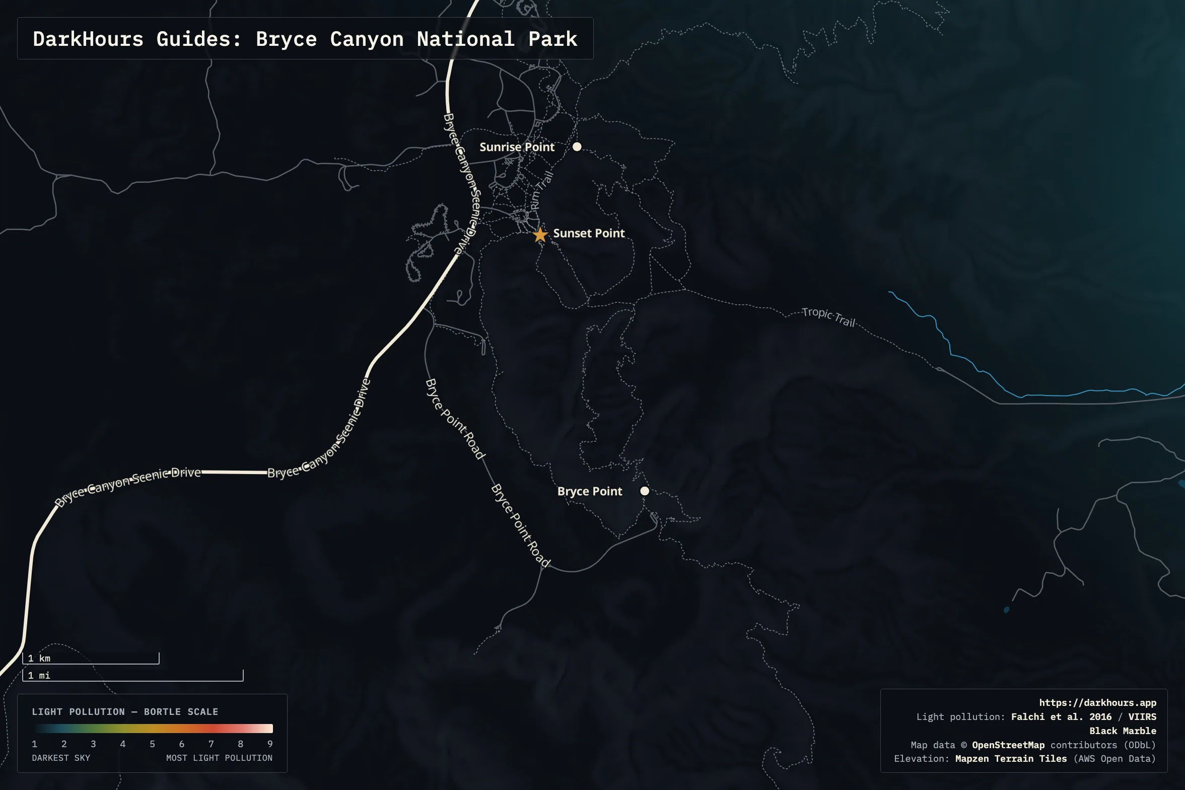
- Sunset Point — This page's reference location, Sunset Point, is a short walk from Bryce Canyon Lodge and its parking area. The park runs ranger led night sky telescope programs from here, because it's an easy, reliable stargazing stop. The overlook opens onto the whole amphitheater, with good sky in every direction.
- Sunrise Point — Sunrise Point is 0.5 miles (0.8 kilometers) to the north of Sunset Point along the Rim Trail, which NPS calls the easiest section of the trail, walkable from either end.
- Bryce Point — About 2.2 miles (3.5 kilometers) south of Sunset Point at the Rim Trail's southern end is Bryce Point, passing Inspiration Point at the 0.7 mile mark. It sits higher and farther from the lodge than the other three amphitheater overlooks, and features a wider, more exposed view across the full basin.
Logistics & Access
Bryce Canyon's private vehicle entrance pass is $35 as of this writing; check the official fees page for the current rate. The park doesn't take cash. A free shuttle is optional, but highly recommended by NPS. It runs roughly April through mid-October during daytime hours. For night visits, driving is the only option. Vehicles 23 feet (7 m) or longer can't park at Sunrise Point, Sunset Point, Inspiration Point, Bryce Point, Bryce Lodge, or the Visitor Center 1 hour Parking Lot during shuttle hours, and can't park at Paria View at any hour. NPS points them to the Additional Parking Lot across from the Visitor Center and the Shuttle Station lot in Bryce Canyon City. Altitude and cold are the two things most likely to catch visitors off guard. NPS's safety guidance states that the park's elevation reaches as high as 9,115 ft. Pace yourself, especially walking between overlooks in the dark. The same page calls out bad footwear as the top cause of rescues and hospital visits in the park. Wear real hiking shoes if you're covering any distance along the rim. In winter, NPS strongly recommends traction devices for all areas of the park. Additionally, lightning is a year round danger. Seek shelter immediately if you hear thunder.
Stay on the trail and back from the rim, especially in the dark. The Rim Trail runs directly along the amphitheater's edge between Sunset, Sunrise, Inspiration, and Bryce Points, and NPS's safety guidance calls for staying on designated trails and away from cliff edges where footing gets uncertain. That's easy to lose track of when you're focused on a tripod and a dark viewfinder. Know where the edge is before you start shooting, not after.